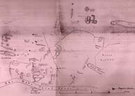

The map is displayed with north at the top. Distance from top to bottom of the map is around two miles; the enormous zone which was to prove most fruitful in the search for papyri is marked ‘Roman mounds’, NW of the modern village and roughly in the centre of the frame. There were no houses here; this was the main ancient rubbish dump. The ancient town buildings, of which little is left and even less visible, lay closer to the modern village, roughly in a half-mile-radius semi-circle around it; see the modified map. Note the D-shaped mound not quite half a mile west of the modern village: this appears as a temple on the revised plan, but was part excavated by Petrie and found to be a huge theatre.
Just over half a mile north of the modern village, ‘slag’ is marked on this map; this area was investigated in excavations in the 1980s and proved to be an industrial zone with large numbers of pottery kilns.
Unpublished